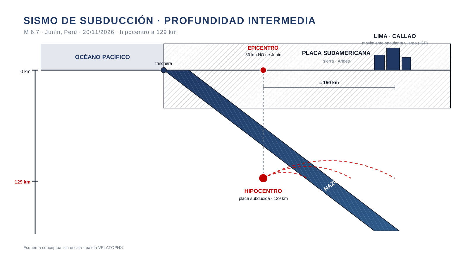
El 20 de noviembre de 2026, a las 23:55 hora local, un sismo de magnitud 6.7 sacudió la sierra central del Perú. El Instituto Geofísico del Perú (IGP) ubicó el epicentro unos 30 km al noroeste de Junín y, dato clave, reportó una profundidad de 129 km. El movimiento se sintió largo e intenso en Lima y el Callao, a más de 150 km del epicentro, y hubo reportes de percepción incluso en Colombia. No se reportaron víctimas de inmediato, y los balances posteriores hablaron de daños menores.
A simple vista hay una aparente paradoja: un sismo de 6.7 sin una catástrofe superficial. La explicación está bajo tierra. A 129 km de profundidad el sismo ocurrió dentro de la placa de Nazca ya subducida, lejos de la superficie, y eso cambia por completo cómo se siente y qué daña. Es una lección de ingeniería sísmica que conviene repasar en México, donde la costa del Pacífico enfrenta sismos de subducción de profundidades muy distintas.
Un sismo de profundidad intermedia: por qué se sintió tan lejos
Bajo la costa peruana, la placa de Nazca se hunde debajo de la placa Sudamericana a razón de varios centímetros por año. La placa que desciende conserva rigidez hasta grandes profundidades y sigue rompiéndose: son los sismos de la zona de Wadati-Benioff. Los que ocurren entre 70 y 300 km se llaman de profundidad intermedia, y el de Junín, con sus 129 km, cae justo en esa categoría.
Esa profundidad explica lo que se vivió en Lima. La energía de un sismo profundo recorre un camino mucho más largo hasta la superficie, y en ese trayecto las ondas de periodo corto —las que sacuden con brusquedad y dañan muros— se atenúan más rápido que las de periodo largo. El resultado es un movimiento percibido como ondulante y prolongado, tal como lo describió el IGP, sentido en un área enorme pero con menos sacudida violenta concentrada en el epicentro.
Profundidad, magnitud y daño: no son lo mismo
La magnitud mide la energía liberada en la fuente; no dice por sí sola cuánto se va a dañar una ciudad. El daño depende de la profundidad, la distancia, el mecanismo de falla, el tipo de suelo y la vulnerabilidad de las construcciones. Un sismo superficial de la misma magnitud concentra la energía cerca del epicentro y suele ser más destructivo; uno de profundidad intermedia la reparte en una región mucho mayor.
| Característica | Superficial (< 70 km) | Intermedio (Junín, 129 km) |
|---|---|---|
| Sacudida cerca del epicentro | Muy intensa, periodos cortos | Menos intensa, periodos largos |
| Área de percepción | Limitada | Muy amplia (varias regiones y países) |
| Daño típico | Concentrado, grave en el epicentro | Repartido, en general menor |
| Estructuras más exigidas | Bajas y de mediana altura, muros | Altas y flexibles, suelos blandos |
Periodos largos: dónde pega un sismo profundo
Como el movimiento de un sismo profundo llega dominado por periodos largos, golpea con más fuerza a las estructuras que vibran en ese rango: edificios altos, torres esbeltas, puentes de grandes claros y suelos blandos que amplifican las frecuencias bajas. El sismo de Junín se percibió con claridad en edificios de Lima y el Callao, donde abundan las construcciones de media y gran altura.
Para el aislamiento sísmico esto tiene una consecuencia directa. Aislar alarga el periodo de la estructura y reduce la aceleración que recibe, pero el precio es un desplazamiento en la base: si el sismo trae mucha energía de periodo largo, el desplazamiento de diseño del aislador crece, y con él el foso, las juntas y las holguras. Por eso el diseño no se hace con un solo valor de aceleración, sino con el espectro completo del sitio, incluida la amenaza de sismos profundos.
Lecciones para la costa del Pacífico de México
Perú y México comparten geología: ambos viven sobre una zona de subducción activa. La trinchera Mesoamericana, frente a Colima, Jalisco, Guerrero, Oaxaca y Chiapas, genera sismos de profundidad variable, desde los superficiales de la interfase hasta los intermedios de la placa que se hunde. Un proyecto en Manzanillo, por ejemplo, debe contemplar ambos tipos.
La lección del 20 de noviembre es de método: caracterizar el peligro por su espectro y su contenido de periodos, no por un solo número. Un sismo profundo puede no romper muros y aun así imponer desplazamientos grandes a un edificio aislado o a una estructura esbelta.
Lista de verificación para el proyectista
- ¿El estudio de peligro incluye sismos de profundidad intermedia y profunda de la zona de subducción, no solo los superficiales?
- ¿El espectro de diseño representa el contenido de periodos largos del sitio?
- ¿Se verificó la estructura para el periodo largo (edificios altos, suelos blandos)?
- Si el proyecto es aislado, ¿el desplazamiento de diseño cubre el escenario de periodo largo?
- ¿El foso, las juntas y las instalaciones tienen holgura para ese desplazamiento?
- ¿Se revisó la respuesta de elementos no estructurales (fachadas, plafones, equipos) ante movimientos prolongados?
En VELATOPH®
VELATOPH® fabrica en Manzanillo, Colima, aisladores LRB de 300 a 1,500 mm de diámetro con amortiguamiento efectivo del 20 al 35 %; LDRB de bajo amortiguamiento (3 a 5 %); y DEF de 50 a 5,000 kN, además de péndulos FPS/DFP y disipadores DVF. El diseño se apoya en ASCE 7-22, ISO 22762, NTC-CDMX 2023, CFE-Sismo 2015 y AASHTO, y considera el espectro completo del sitio, incluida la amenaza de sismos de subducción profundos.
Si proyectas o revisas una estructura expuesta a sismos de subducción —en México o en la costa del Pacífico—, ofrecemos una evaluación técnica gratuita por WhatsApp. También puedes leer las notas sobre cómo leer un espectro de diseño, el desplazamiento máximo del aislador y la interacción suelo-estructura en suelos blandos.
Fuentes
- IGP / Agencia Andina. Temblor en Junín: IGP explica por qué en Lima el movimiento fue ondulante y largo. andina.pe
- El Peruano (diario oficial del Perú). Sismo de magnitud 6.7 con epicentro en Junín remeció casas y edificios de Lima y Callao. elperuano.pe
- EFE. Un sismo de 6,7 sacude el centro de Perú y se siente en Lima. efe.com
- AP News. Magnitude 6.7 earthquake shakes Andes in central Peru. apnews.com
- USGS. Earthquake Hazards Program. earthquake.usgs.gov
Artículo de carácter general y educativo; no sustituye el diseño ni la revisión de un ingeniero responsable de cada proyecto, ni las indicaciones de la autoridad competente.
On November 20, 2026, at 11:55 pm local time, a magnitude 6.7 earthquake shook the central highlands of Peru. The Instituto Geofísico del Perú (IGP) placed the epicenter about 30 km northwest of Junín and, a key detail, reported a depth of 129 km. The shaking was felt as long and intense in Lima and Callao, more than 150 km from the epicenter, and there were reports of it being felt even in Colombia. No casualties were reported immediately, and later assessments spoke of minor damage.
At first glance there is an apparent paradox: a magnitude 6.7 with no surface catastrophe. The explanation lies underground. At 129 km deep, the earthquake occurred inside the already-subducted Nazca plate, far from the surface, and that completely changes how it is felt and what it damages. It is an earthquake-engineering lesson worth revisiting in Mexico, where the Pacific coast faces subduction earthquakes of very different depths.
An intermediate-depth earthquake: why it was felt so far away
Beneath the Peruvian coast, the Nazca plate sinks beneath the South American plate at a rate of several centimeters per year. The descending plate keeps its stiffness to great depths and keeps breaking: these are the Wadati-Benioff zone earthquakes. Those that occur between 70 and 300 km are called intermediate-depth, and the Junín event, at 129 km, falls exactly in that category.
That depth explains what was experienced in Lima. The energy of a deep earthquake travels a much longer path to the surface, and along that path the short-period waves —the ones that shake violently and damage walls— attenuate faster than the long-period ones. The result is motion perceived as rolling and prolonged, just as the IGP described it, felt over a huge area but with less violent shaking concentrated at the epicenter.
Depth, magnitude and damage are not the same thing
Magnitude measures the energy released at the source; on its own it does not tell how much a city will be damaged. Damage depends on depth, distance, faulting mechanism, soil type and the vulnerability of the buildings. A shallow earthquake of the same magnitude concentrates its energy near the epicenter and tends to be more destructive; an intermediate-depth one spreads it over a much larger region.
| Characteristic | Shallow (< 70 km) | Intermediate (Junín, 129 km) |
|---|---|---|
| Shaking near the epicenter | Very intense, short periods | Less intense, long periods |
| Felt area | Limited | Very wide (several regions and countries) |
| Typical damage | Concentrated, severe at the epicenter | Spread out, generally lower |
| Most challenged structures | Low- and mid-rise, walls | Tall and flexible, soft soils |
Long periods: where a deep earthquake hits hardest
Because the motion of a deep earthquake arrives dominated by long periods, it strikes hardest the structures that vibrate in that range: tall buildings, slender towers, long-span bridges and soft soils that amplify low frequencies. The Junín earthquake was felt clearly in buildings across Lima and Callao, where mid- and high-rise construction is common.
For seismic isolation this has a direct consequence. Isolating lengthens the structure's period and reduces the acceleration it receives, but the price is displacement at the base: if the earthquake carries a lot of long-period energy, the isolator's design displacement grows, and with it the moat, the joints and the clearances. That is why design is not done with a single acceleration value, but with the site's full spectrum, including the threat of deep earthquakes.
Lessons for Mexico's Pacific coast
Peru and Mexico share geology: both sit on an active subduction zone. The Middle America Trench, off Colima, Jalisco, Guerrero, Oaxaca and Chiapas, generates earthquakes of variable depth, from shallow interface events to intermediate ones in the sinking plate. A project in Manzanillo, for example, must account for both kinds.
The lesson of November 20 is one of method: characterize the hazard by its spectrum and its period content, not by a single number. A deep earthquake can leave walls standing and still impose large displacements on an isolated building or a slender structure.
Checklist for the design engineer
- Does the hazard study include intermediate- and deep-focus subduction earthquakes, not only shallow ones?
- Does the design spectrum represent the site's long-period content?
- Was the structure checked for the long period (tall buildings, soft soils)?
- If the project is isolated, does the design displacement cover the long-period scenario?
- Do the moat, the joints and the services have clearance for that displacement?
- Was the response of nonstructural elements (façades, ceilings, equipment) checked for prolonged motion?
At VELATOPH®
VELATOPH® manufactures in Manzanillo, Colima, LRB isolators from 300 to 1,500 mm in diameter with effective damping from 20% to 35%; low-damping LDRB (3% to 5%); and DEF from 50 to 5,000 kN, plus FPS/DFP pendulums and DVF dampers. Design relies on ASCE 7-22, ISO 22762, NTC-CDMX 2023, CFE-Sismo 2015 and AASHTO, and considers the site's full spectrum, including the threat of deep subduction earthquakes.
If you design or review a structure exposed to subduction earthquakes —in Mexico or along the Pacific coast— we offer a free technical assessment via WhatsApp. You can also read the notes on how to read a design spectrum, the maximum isolator displacement and soil-structure interaction on soft soils.
Sources
- IGP / Agencia Andina. Temblor en Junín: IGP explains why the motion in Lima was rolling and long. andina.pe
- El Peruano (Peru's official gazette). Magnitude 6.7 earthquake with epicenter in Junín shook homes and buildings in Lima and Callao. elperuano.pe
- EFE. A 6.7 earthquake shakes central Peru and is felt in Lima. efe.com
- AP News. Magnitude 6.7 earthquake shakes Andes in central Peru. apnews.com
- USGS. Earthquake Hazards Program. earthquake.usgs.gov
General, educational article; it does not replace the design or review by an engineer responsible for each project, or the instructions of the competent authority.